


- About Parks Division
- Legislation
- Maps & Shapefiles
- Partners
- Permit Applications
- Publications
- Science & Research
- Research Projects
About Parks Division
The Parks Division of Newfoundland and Labrador is responsible for the management, preservation, control, protection and development of provincial parks as defined in the Provincial Parks Act.
The Division has two primary objectives:
- the provision of a diverse range of outdoor recreation opportunities that encourage residents and visitors to discover and appreciate nature, and
- the conservation of biological diversity through the establishment and management of a system of provincial parks.
In addition to camping and outdoor recreation, the Division supports scientific research and monitoring, education and sustainable tourism activities in provincial parks. The benefits of the Province’s parks extend beyond conservation and outdoor recreation to include economic activity generated by government and visitor spending, rural employment, physical and mental health, green spaces, ecosystem services, and climate change adaptation and mitigation.
Network of Provincial Parks
There are a total of 32 provincial parks in the province. They represent some of our most scenic landscapes and were chosen to provide protection for the fantastic flora and fauna that can be found there. At the same time, these parks provide the public with a variety of opportunities for recreation in the great outdoors against a backdrop of breathtaking natural beauty.
Camping Parks (13)
Of the thirteen camping parks, three are keystone. These are located along the Trans Canada highway and have in excess of 100 campsites. The ten remaining are regional parks, found along rural routes and containing less than 100 campsites. All thirteen, however, share the same goal: to protect and provide significant provincial destinations within the province. They protect and offer distinctive natural features and visitor experiences for both residents and out-of-province visitors.
Day Use Areas (7)
These parks provide access and protection to those beaches, vistas and natural features in the province that possess extraordinary qualities. These provincial parks are perfect stops for both residents and out-of-province visitors.
T’Railway (1)
This linear park consists of approximately eight hundred kilometers of the former Canadian National Railway, stretching from Port Aux Basques to Mount Moriah on the west coast and then from Pasadena to St. John’s on the east coast. It provides an all season, multi-use recreational corridor, developed and managed in consultation with community partners to maximize adventure tourism and recreation opportunities. It also has been identified as part of The Great Trail of Canada.
Waterway Park (1)
Waterway parks are established to preserve significant rivers or sections of such rivers including headwaters, tributaries, and/or intermediate linking lakes, together with adjacent land for recreational purposes and/or protection. The Main River Canadian Heritage River was designated as the province’s first Waterway Provincial Park in 2009. The mighty Main provides opportunities for backcountry camping, hiking and, for the white water expert, kayaking and canoeing.
Park Reserves (10)
The 10 park reserves in this province protect areas with significant natural features and landscapes. While they do not offer any visitor services, they are important conservation areas in the province.
Legislation
Provincial Park Proclamations and other regulations
Maps & Shapefiles
GIS Data Disclaimer
Note: The boundaries included in the data are graphical representations and are not intended to be used as a legal definition. The official record remains the order published in the Newfoundland Gazette. All users should consult legislative references when exact land descriptions are required.
See the Open Government Licence for Newfoundland and Labrador.
Partners
The Parks Division enjoys many longstanding and newly minted partnerships with organizations across Newfoundland and Labrador. Please visit any of the below for more information on their organizations and how they add to our Provincial Park experience.
Canadian Parks Council
Avalon Nordic Ski Club
Grand Fairways Resort
Grande Meadows Golf Course
Humber Lodge Big Falls
Kittiwake Cottages
T’Railway Provincial Park:
- City of St. John’s
- City of Mount Pearl
- Newfoundland and Labrador Snowmobile Federation
- Newfoundland T’Railway Council
- Town of Conception Bay South
- Town of Avondale
- Town of Channel-Port Aux Basques
Permit Applications
Provincial Parks offer numerous opportunities to host special events, conduct research and enjoy the natural beauty of Newfoundland and Labrador.
- Group Camping Application
- Scientific Research Application
- Special Event Application
- T’Railway Provincial Park Permit Application
Publications
The geography of Newfoundland and Labrador is as varied as it is beautiful. Here you can find nearly twenty ecoregions and a host of unique geology, flora and fauna.
Ecoregion Brochures
Note: all links below are PDFs and will open in a new window.
Newfoundland
- Western Newfoundland Forest – Serpentine Range subregion 1A (807 KB)
- Western Newfoundland Forest – Corner Brook subregion 1B (928 KB)
- Western Newfoundland Forest – Port au Port subregion 1C (881 KB)
- Western Newfoundland Forest – St. George’s Bay subregion 1D (744 KB)
- Western Newfoundland Forest – Codroy subregion 1E (787 KB)
- Western Newfoundland Forest – Bay d’Espoir subregion 1F (846 KB)
- Central Newfoundland Forest – North-central subregion 2A (872 KB)
- Central Newfoundland Forest – Red Indian Lake subregion 2B (977 KB)
- Central Newfoundland Forest – Portage Pond subregion 2C (902 KB)
- Central Newfoundland Forest – Twillick Steady subregion 2D (898 KB)
- North Shore Forest 3 (931 KB)
- Northern Peninsula Forest – Coastal Plain subregion 4A (889 KB)
- Northern Peninsula Forest – Beaver Brook Limestone subregion 4B (997 KB)
- Northern Peninsula Forest – Northern Coastal subregion 4C (863 KB)
- Northern Peninsula Forest – Eastern Long Range subregion 4D (887 KB)
- Avalon Forest 5 (1 MB)
- Maritime Barrens – Northeastern Barrens subregion 6A (876 KB)
- Maritime Barrens – Southeastern Barrens subregion 6B (1.1 MB)
- Maritime Barrens – South Coast Barrens subregion 6C (1 MB)
- Maritime Barrens – Central Barrens subregion 6D (986 KB)
- Eastern Hyper – Oceanic Barrens 7 (862 KB)
- Long Range Barrens – Southern Long Range subregion 8A (1 MB)
- Long Range Barrens – Buchans Plateau/Topsails subregion 8B (1 MB)
- Long Range Barrens – Northern Long Range subregion 8C (783 KB)
- Strait of Belle Isle Barrens 9 (761 KB)
Labrador
- Low Arctic Tundra – Cape Chidley ecoregion 1 (839 KB)
- Alpine Tundra – Torngat ecoregion 2 (733 KB)
- High Subarctic Tundra – Kingurutik/Fraser ecoregion 3 (794 KB)
- Coastal Barrens – Okak/Battle Harbour ecoregion 4 (681 KB)
- Mid Subarctic Forest – Michakamau ecoregion 5 (729 KB)
- High Boreal Forest – Lake Melville ecoregion 6 (957 KB)
- Mid Boreal Forest – Paradise River ecoregion 7 (751 KB)
- Low Subarctic Forest – Mecatina River ecoregion 8 (816 KB)
- String Bog – Eagle River Plateau ecoregion 9 (762 KB)
- Forteau Barrens ecoregion 10 (637 KB)
Natural Heritage
- Animal Tracks (866 KB)
- Newfoundland Sky in Summer (775 KB)
- Our Feathered Friends (968 KB)
- Peatland Flowers (799 KB)
- Special Spaces; Special Species (1.1 MB)
- The endangered Piping plover and its ecosystem (2 MB)
- Wild about wildflowers (1.3 MB)
- Woodland Flowers (563 KB)
Science & Research
Provincial parks are excellent places to conduct scientific research and the Parks Division certainly encourages applications. This research is invaluable in understanding all the ways we interact with, affect and are affected by the natural world. It helps to shed light on how our natural systems function, cope, thrive, fail and adapt.
Guidelines
Research in provincial parks requires authorization by the Parks Division. Researchers must apply for a scientific research permit, and carry it with them when conducting research in a provincial park.
Applications are evaluated by the Parks Division. The criteria used include:
- the purpose of the research and the proposed methodology,
- whether the project duplicates work already completed or currently underway,
- the scientific credentials of the researchers, and
- how the results of the study might help management of the park.
Conditions of a scientific research permit include compliance with the legislation (Provincial Parks Act and associated regulations). Generally, all scientific work must be non-invasive and non-intrusive—it cannot be done in a way that destroys or diminishes the park or its flora or fauna.
There are a few exceptions to the regulations for researchers, such as collecting specimens, which are outlined in the appropriate regulations and may also be listed on the permit. Other conditions may also apply. Multi-year permits may be requested, to a maximum of three years.
Permits
Anyone conducting scientific research and/or monitoring in a park must have a valid scientific research permit. The information required for a permit application includes the following details about the proposed study:
- title,
- objective(s),
- detailed description of the proposed methodology, including full disclosure of any proposed removal or displacement of materials (plants, insects, animals, sand, etc.),
- expected duration, with start and end dates of both fieldwork and final analysis,
- the names, positions, affiliations, and professional/technical qualifications of all individuals involved, and
- copies of any other permits required (e.g. Canadian Wildlife Service, Animal Care, Wildlife Division).
If a permit is granted and the project proceeds, researchers must submit to the Parks Division:
- a Field Report one month after their field season has ended,
- a Final Report by January 31 following the final year of the research, and
- copies of any published material resulting from the work.
Other conditions may also apply. There is no fee for a permit.
For more information on scientific research permits, or if you have any questions, please contact Parks Division at info@parksnl.ca
Important Note: Allow a minimum of three weeks for your application to be processed.
Research Projects – Spotlights
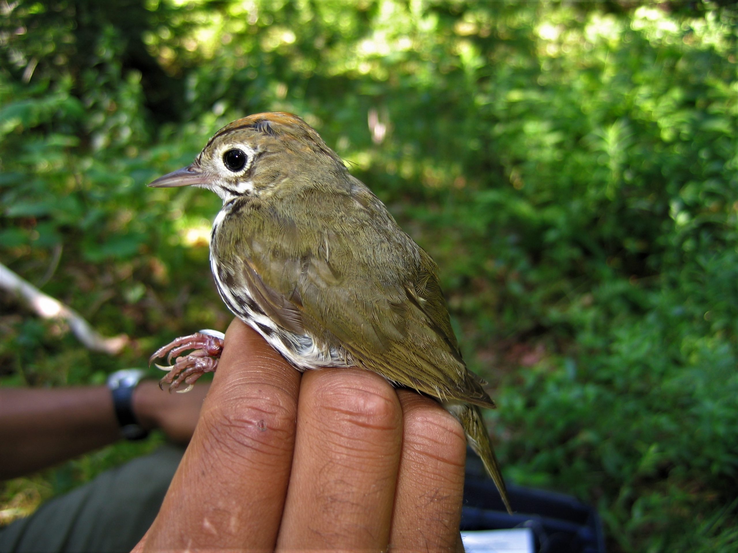
1. The Monitoring Avian Productivity and Survivorship (MAPS) Program is a continent-wide collaborative effort among public agencies, non-governmental groups, and individuals to assist the conservation of birds and their habitats through demographic monitoring. About 500 stations are run across North America on an annual basis. The MAPS station in Barachois Pond Provincial Park is the only active MAPS site in Newfoundland and Labrador This site has been run continuously since 2011 and has contributed longterm data to the MAPS monitoring network.
MAPS stations are run over the summer breeding season, using a standardized array of fine mesh nets to safely catch birds. Captured birds are identified to species and banded. Data is also collected on age, sex, body condition, and reproductive status of the birds before they are released. Any birds detected at the station and their associated breeding status, are also recorded. To date, 51 bird species have been recorded and over 1,180 birds have been captured. Many of these birds are recaptures between years, providing important survivorship information. Warblers, sparrows, woodpeckers, chickadees, kinglets and thrushes are some of the more commonly encountered bird groups.
For more information on the MAPS program, please visit MAPS.
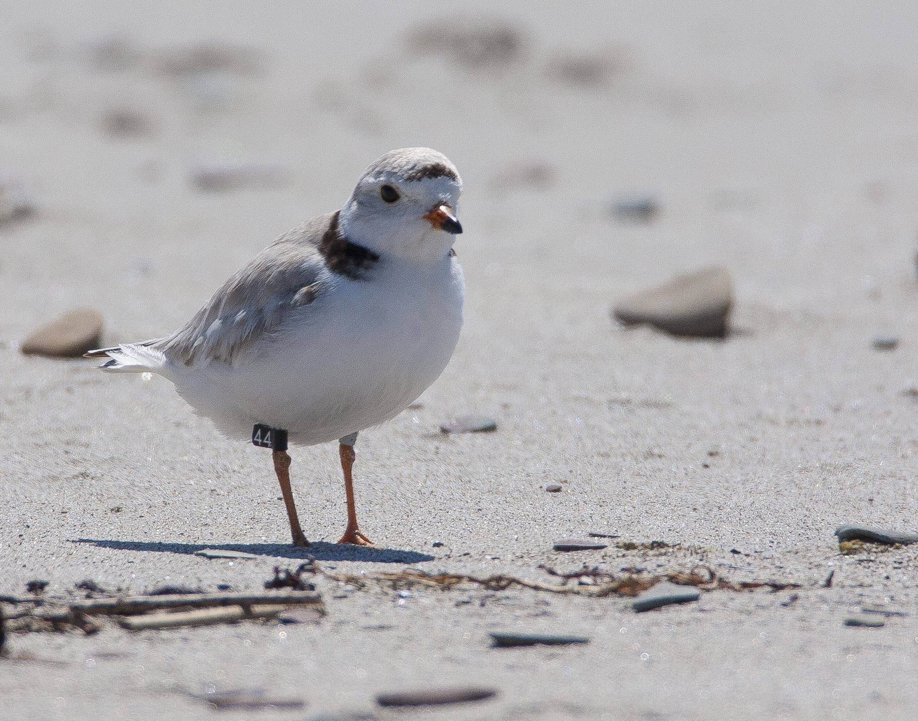
2.Piping Plover Monitoring
Each spring and summer, monitoring groups are out across Eastern Canada’s beaches (NL, NS, PE, NB, and QC) looking to spot endangered Piping Plover. The aim is to count birds to track the recovery of this population, but also to protect nesting sites from potential conflict with human activities. Birds face a variety of threats on the beach including disturbance, human harassment, destruction of habitat and predation. Conservation groups work with communities and encourage people to share beaches with wildlife and reduce threats to beach-going birds. In NL, many Piping Plover beaches have heavy vehicle traffic which may harass adults and chicks or even directly harm eggs or young birds.
A major initiative currently underway and led by Environment and Climate Change Canada is a multi-year international research project involving banding Piping Plover on the breeding grounds and re-sighting the birds throughout the year (including migration and winter). ECCC initiated the study because of a dramatic population decline of more than 30% observed over a ten-year period (2002-2012). A review of the local conservation program at that time suggested that factors outside of the breeding season were likely the principle cause for the decline. To inform next steps, ECCC initiated the study to assess survival rates across the annual cycle better and better understand where birds go outside the breeding season to determine where and when birds were most at risk. Fortunately, population levels in NL and the rest of Atlantic Canada have remained stable since 2012. However, nest productivity in NL has been low over the past few years, which means Piping Plover pairs are not producing very many fledglings to replenish the population.
The bulk of data collection for the re-sighting project will end in 2021 and thanks to a collective effort across the species range, ECCC will be able to better inform and direct conservation efforts to protect this species throughout the annual lifecycle. Efforts to protect birds on Eastern Canada’s beaches remain a critical component of this conservation program but protecting birds year-round, especially at key sites visited during migration and winter will be an important step towards ensuring recovery.
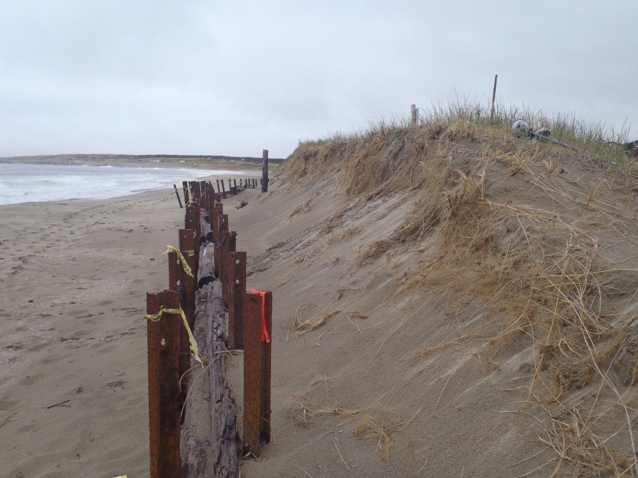 3. Coastal Change Change along our coastline is inevitable, and the coastline has been evolving for thousands of years. Most natural processes that affect our coasts are gradual. On a cliff, wind can blow sand particles from a cliff face, and groundwater and surface water can wash material down onto the beach. Other processes, such as landslides, are rapid, and a cliff face can retreat by many metres in just a few seconds. Coastal change can impact upon anthropogenic coastal features, such as walking trails or wharfs, erode culturally significant features such as fossils, or modify the type of beach sediment, impacting critical habitats such as bird-nesting areas. Coastal change will continue, as the sea level is rising and our climate is getting warmer, wetter, and with more frequent and larger storms.
The Geological Survey is studying coastal areas across the province, inclusive of protected areas, to better understand the nature of coastal change and its potential impacts on coastal systems. Through repeated surveys of selected coastal areas, rates of coastal change are being quantified and the processes causing change identified. This information can be used to make more informed decisions regarding land use in coastal environments.
At the J.T. Cheeseman Provincial Park the coastal area includes sand dunes. Wind has removed loose sand from face of the dunes, in particular in areas of sparse vegetation, and waves have moved sand off the beach face, depositing it in the nearshore. In part of the beach, the seaward edge of a dune was eroded by over 30 feet in one year. Codroy Valley Provincial Park also includes a large sand-dominated beach. At the back of the beach is a dune system; the face of the dunes is primarily non-vegetated, and wind has removed loose sand, resulting in the dunes being eroded up to 57 cm in one year. Erosion has also occurred at Sandbanks Provincial Park, an extensive sandy beach system west of Burgeo. Along part of the beach, a dune has been eroded by over 550 cm (18 feet) in one year. Over several decades, the coast in these three areas will continue to erode, as sediment loss is exceeding sediment gain.
Photo caption:
The Geological Survey of Newfoundland and Labrador has been studying coastal changes for over two decades. In the past, we’ve measured eroding cliffs using survey equipment, and now we use drones to collect data. The drones take a series of photos that we process to give us a very high-resolution image of our study area. By repeating the flight at a later date, we can overlay and compare the two images to determine the rate of erosion. At J.T.Cheeseman Provincial Park, wind has removed sand off the face of the sand dune, exposing old railway infrastructure.